Satellite Land-Cover
Why zero-shot fails on satellite tiles: a clear lesson in domain shift.
Classifies Sentinel-2 satellite tiles (64×64 px, 10 m per pixel) into 10 land-cover types: crops, forest, vegetation, highway, industrial, pasture, residential, river, sea/lake. A fine-tuned ResNet-18 reaches 98 % test accuracy on a laptop CPU, while zero-shot CLIP, which beat a trained detector in project 17, manages only 47 %. A clear lesson about domain shift.
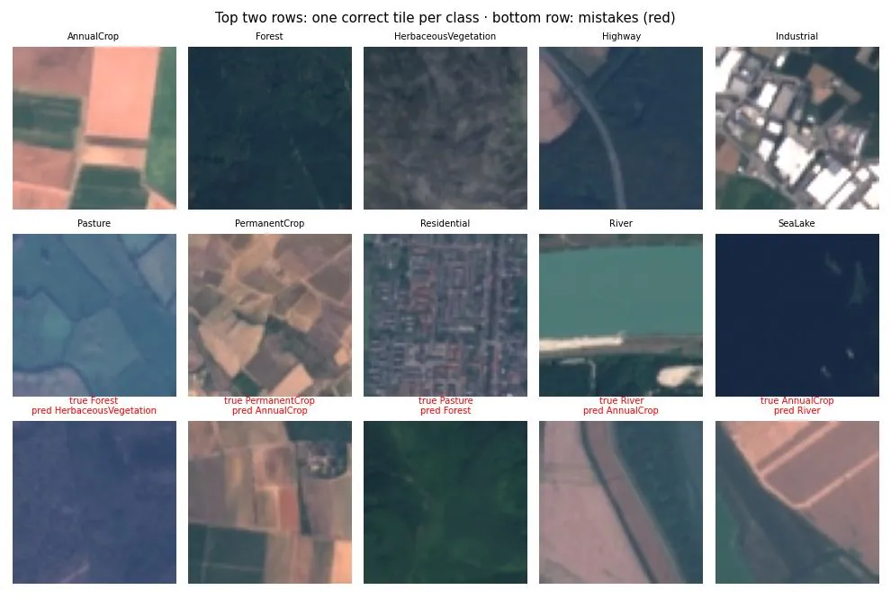
Top two rows: one correct tile per class. Bottom row: mistakes, mostly tiles that mix two land types (river and fields) or similar crop types.
Results
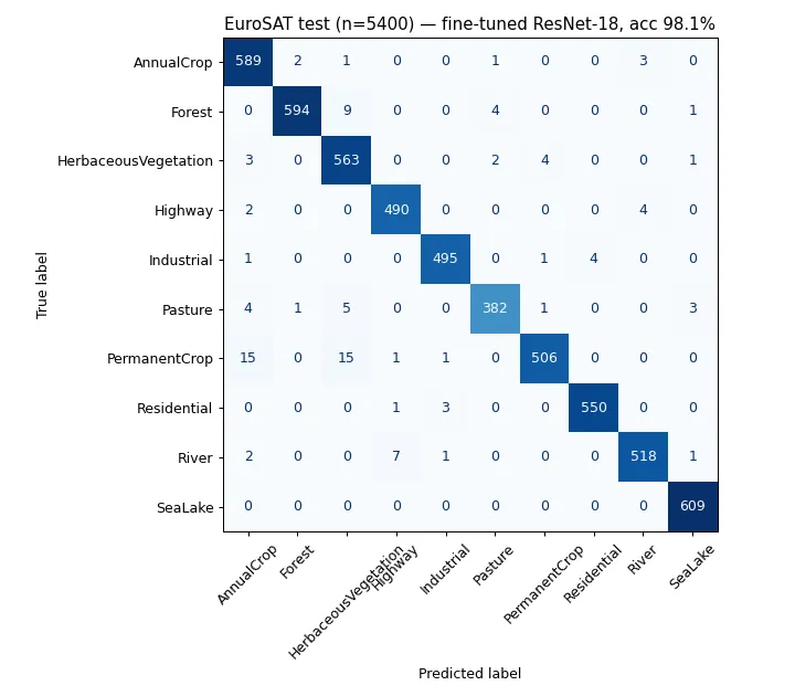
Standard EuroSAT RGB split, test set of 5,400 tiles.
| Model | Training on EuroSAT | Test accuracy | Macro F1 | CPU time / tile |
|---|---|---|---|---|
| ResNet-18 fine-tuned | 16,200 tiles, 6 epochs | 98.07 % | 0.981 | 15.5 ms |
| CLIP ViT-B/32 zero-shot | none (text prompts only) | 47.44 % | — | 62.8 ms |
Per-class F1 (fine-tuned): every class ≥ 0.964. Best: SeaLake 0.995, Residential 0.993; hardest: PermanentCrop 0.964, HerbaceousVegetation 0.966.
Why zero-shot fails here (and didn’t in project 17)
| Class | CLIP zero-shot accuracy |
|---|---|
| Residential | 93.9 % |
| Industrial | 86.0 % |
| PermanentCrop | 72.1 % |
| Highway | 59.3 % |
| … | … |
| Forest | 17.8 % |
| HerbaceousVegetation | 0.7 % |
CLIP learned from internet photos with captions. Buildings from above appear in such photos, so it recognizes Residential and Industrial; but a 64-pixel dark green square labeled “forest” looks nothing like the forests in its training data. In project 17 (COCO photos), zero-shot Grounding DINO beat a supervised YOLO. Zero-shot models are strong in-domain and weak out-of-domain; for specialized imagery (satellite, medical, industrial), a small fine-tuned model wins easily.
How it works
- Data: tiles are decoded once into RAM (the whole set is tiny), then upsampled from 64 to 128 px so ImageNet filters see familiar scales.
- Augmentation: horizontal/vertical flips and 90° rotations (satellite images have no “up”), plus brightness/contrast jitter.
- Model: ResNet-18 (ImageNet weights,
timm), new 10-class head, AdamW + one-cycle learning rate, label smoothing 0.05, 4 CPU threads (the performance cores, see project 19). - Zero-shot baseline: OpenCLIP ViT-B/32 (same model as project 16) with prompts
"a satellite photo of {class}."; the class with the highest image-text similarity wins.evaluate.pyreuses the model settings from../16-text-to-image-search/clip_search.py, so that folder (and itsfaiss-cpudependency) must be present.
Data
- EuroSAT RGB (Helber et al., 2019): 27,000 labeled Sentinel-2 tiles, 10 classes; Hugging Face
mirror
timm/eurosat-rgb(MIT) with the standard 16,200 / 5,400 / 5,400 split. - Location:
../../cv-data/eurosat/(not committed).
Run it
.venv\Scripts\activate            # shared environment, from the repo root
cd 12-satellite-land-cover
python train.py --epochs 6        # ~1 h on an idle CPU
python evaluate.py                # test accuracy, CLIP zero-shot, figures
What I learned / what didn’t work
- 98 % in 6 epochs. EuroSAT is close to solved; published ResNet results are in the same range, which makes it a good sanity check but not much of a challenge.
- The remaining errors are label ambiguity, not model failure: a 640 m × 640 m tile often contains two land types, and the label is the dominant one.
- Domain shift decides zero-shot quality (see above): the most useful finding of this project.
- Training time varied from 8 to 55 minutes per epoch because other jobs shared the CPU; on an idle CPU an epoch takes ~8–10 minutes.
- This is classification of whole tiles, not pixel-level segmentation. The original plan (LoveDA segmentation) needed 8 GB of data; EuroSAT fit the constraints.
Next steps
- Use all 13 Sentinel-2 spectral bands (EuroSAT MS): near-infrared separates vegetation types far better than RGB.
- Slide the classifier over a large satellite scene to produce a coarse land-cover map.
- Pixel-level segmentation on a larger dataset with a GPU.
Tech stack
Python · PyTorch · timm (ResNet-18) · OpenCLIP · scikit-learn · pyarrow